August 12, 2008
Class 2; Elevation Gain 4,300 ft
The end of an era…
From the moment we pulled into the Moosehead Lodge in Baxter State Park Mount Katahdin was to be the start of our “High Peaks Tour” and Julie and Tim’s farewell to the northeast. We were not only embarking on more challenging hiking than we had previously experienced, but two of our three members were getting ready to move to the “left coast”.
 We pulled in, chose our campground, set up our tents, and headed for the ranger’s station to check out some additional maps and trail advice. The ranger warned us not to take the Knife Edge trail, but when we insisted that it was a major goal of our trip, he suggested we should take extra flashlights (“…because if you have them, you won’t need them”).
 We chatted some more, confirmed our route, looked over the 3-dimensional model of Mount Katahdin and went in search of the nearest supermarket. As we were hunting for steak, turkey burgers, beans, and hotdogs (purchasing food for a week of hiking in Maine and New Hampshire America
The following morning, we set out early and headed to the trailhead. Although we always have them, we heeded the ranger’s advice to take extra flashlights. The start of the hike was damp, yet pleasant. Once we hit the field of boulders, the terrain quickly changed. Jim was the only one of us that had much previous experience in climbing and bouldering. Although it wasn’t terribly treacherous bouldering, it was a little nerve-racking for Julie (little did she know what was coming after the summit!).
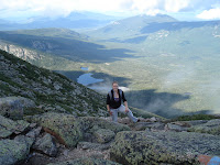
As we continued up, we hit the Cathedrals, all three, and climbed through and above the cloud-line. The Cathedrals were challenging; they were steep, cold, damp, mossy, and lichen-covered. Each was more difficult than the last, with the final Cathedral being close to a vertical scramble.
 |
| Jim at the base of the Cathedrals |
 |
| Our view from above cloudline |
 |
| Getting started on the Cathedrals |
We were thrilled to hit the summit and enjoyed our hummus and pita in the wind, while convincing other hikers to brave the Knife’s Edge trail that we were getting ready to tackle. Supposedly, there was a narrow trail that would wind its way along the side of the Knife Edge. Unfortunately, this trail was just as steep and treacherous as climbing over the serrated edge of the rock.
It was scary; it was stunning.
When we reached the other side, we knew we had accomplished an amazing feat. After tons of pictures and a brief break, we began to make our descent at Pamola. The downward slope felt like it took a life-time and, just our luck, it poured for more than half of our trek. We threw on our rain gear, covered our packs, checked our head lamps and ran the rest of the way to the trailhead, where our car was a safe, dry haven for the weary.
After a quick campfire and dinner, we hit the sack and nursed our sore muscles and knees the entire next day. That night, we strolled to the lodge for dinner, met up with some interesting locals and other hikers, letting them know that “if I never see another rock, it would be too soon.”
Overall, Mount Katahdin was one of the best alpine views we’ve had, as well as our first true physically and emotionally challenging hike.


